
Tupelo to Mathiston, MS
Tuesday, October 7, 2003
We awoke at 6:00 AM this morning, which was a real change, compared to the last several days when we were at Joan's. There we slept until we were ready to wake up and most of the time that was between 7:30 AM and 8:30 AM. By 7:30 AM we were riding south on the Natchez Trace Parkway. We stopped at every historical point of interest. At most of them all you got to see was a sign that explained what happened at that location. We did see a portion of the Old Trace and it is much different from the current trace. The Old Trace looks like this.
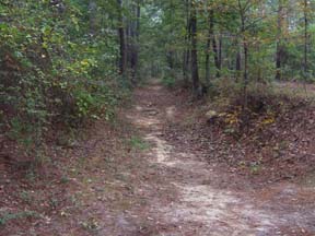 As you can see the road is 3 to 4 feet below the general ground level. The current trace road is a modern two lane highway and looks like this.
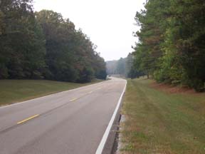 At times the Natchez Trace Parkway is less than 500 feet wide and fields of hay or soybeans are on both sides of the Parkway. At other times it is quite wide and forests as seen in the picture are on both sides of the Parkway. Today was an easy ride with gentle slopes it felt good to be on the bicycles again. We arrived at our motel for the night, which has only smoking rooms. He had three empty rooms so he let us choose the rooms we wanted. Our room is not too bad. We showered and went to supper. It was the worst meal we had since we started the trip. The only meal that came close was the side of buffalo that turned out to be a fish deep-fried so hard that you could not chew it. Mary Kay and Becky had catfish that tasted funny and was very greasy. I had a hamburger steak and it was cold. We went to a convince store where we purchased ice cream to finish our meal. |
Return
Last modified 10/08/03